Cheile Nerei Gorges
Discover Cheile Nerei — Romania's longest gorge system. Explore the Beușnița waterfalls, an ancient Roman trade road, a medieval fortress, and hand-carved cliff tunnels in Caraș-Severin.
Inside Romania's Longest Gorge System and the History Carved Into Its Rock
Tucked into the Anina Mountains of Caraș-Severin County, in Romania's southwestern Banat region, Cheile Nerei (the Nera Gorges) is one of the country's most dramatic and least-crowded natural landmarks. As the centerpiece of Cheile Nerei-Beușnița National Park, this 36,758-hectare protected area combines turquoise karst lakes, cascading waterfalls, and a surprising depth of human history — from Roman trade routes to medieval fortresses to tunnels chiseled by hand into solid rock.
This guide walks through what makes the gorges themselves worth the trip, and unpacks the historical layers most visitors walk straight past.
Where Are the Cheile Nerei Gorges?
The gorges stretch for more than 20 kilometers between the villages of Sasca Română and Șopotu Nou, carved over millennia by the Nera River and its tributaries through limestone bedrock. Caraș-Severin is the only county in Romania with three national parks, and Cheile Nerei-Beușnița is widely considered the wildest of the three — a landscape of narrow ravines, rock tunnels, karst springs, and over 470 recorded caves.
The park sits close to the Romanian-Serbian border, roughly a half-day's drive from Timișoara and a longer haul from central and eastern Romania, which is part of why it has stayed comparatively undiscovered.
The Waterfalls of Cheile Nerei
Water is the defining feature of this landscape, and the park's waterfalls are its most photographed attractions.
Cascada Beușnița is the signature fall: a tiered cascade dropping through moss-covered limestone shelves, with a main drop most sources put between 5 and 15 meters depending on the exact ledge measured. It's fed by the same karst system responsible for the park's blue-green lakes, which is why the water keeps its cold, clear color year-round.
Cascada Vaioaga sits along the approach route from the Valea Beiului forest road, a smaller but striking two-stage drop over about 6 meters.
Cascada Susara rounds out the trio near Sasca Montană, an easier detour for visitors short on time.
Together, these waterfalls form a loop that most hikers combine with a visit to Ochiul Beiului, a spring-fed lake that never freezes, and — for those with a full day — Lacul Dracului (Devil's Lake), a striking pool formed when a cave ceiling collapsed.
A Roman Trade Corridor Through the Mountains
Long before it was a national park, this stretch of the Banat Mountains was part of a functioning Roman road network. During the Roman conquest of Dacia, a commercial road ran from the Danube port of Mudava (present-day Moldova Veche) through the mining settlements of Moldova Nouă and Sasca, continuing on to Ciclova and Oravița before linking up with the region's larger road system toward Bocșa and the fortress at Bersobis (Berzovia).
At Sasca Montană specifically, this commercial route intersected with a road connecting to the main military highway between Dierna (modern Orșova) and Tibiscum, one of the principal arteries the Romans used to move troops and supplies deeper into conquered Dacian territory. In other words, the valleys around Cheile Nerei weren't a backwater — they sat on an actual junction of Roman commerce and administration, tied to the mining economy that made this part of Banat valuable to Rome in the first place.
It's worth noting that the wider Cheile Nerei-Beușnița area also contains documented archaeological sites — settlements, burial mounds, and necropolises — dating to both the Neolithic and Roman periods, confirming that people were settling this terrain for its caves, springs, and river terraces long before any road existed.
The Medieval Fortress and Fortified Church
Where the Roman era left roads and mining settlements, the medieval period left stone. Near the village of Ilidia, close to the southern edge of the park, stands the Socolari fortress, built in the 14th–15th centuries, alongside a fortified church dated to the 13th–14th centuries and an associated necropolis from the 12th–14th centuries.
These structures reflect the Banat's history as a contested frontier zone between the Kingdom of Hungary and, later, the Ottoman Empire — a border region where fortified churches and small hilltop strongholds served both religious and defensive purposes. If you've spotted dry-stacked stone walls on a ridge near the southern trails, this fortress complex is the most likely source, distinct from anything Roman or prehistoric.
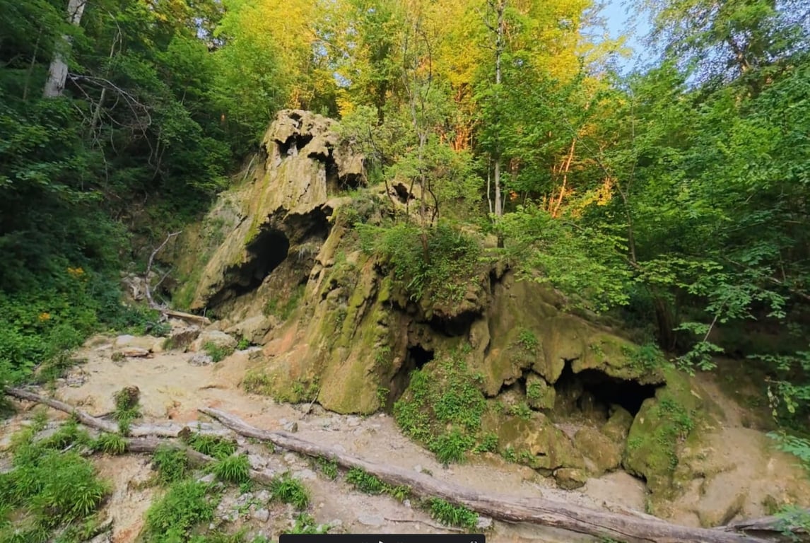
The Carved Tunnels: "La Tunele"
Between Podu Bei and Sasca Română, hikers pass through one of the park's most memorable features: a series of narrow passages hand-carved directly into the cliff face, roughly 15 meters above the Nera River. Locally known as La Tunele, these rock-cut corridors connect otherwise inaccessible stretches of the gorge trail.
Local legend attributes the tunnels to the Ottoman occupation period, dug by villagers to shorten the route between settlements on the river's right bank — a practical piece of folk engineering rather than a state infrastructure project. Some tour operators market them as "Roman tunnels," but this claim isn't backed by the documented history of the site; it appears to be tourism branding rather than an archaeological finding, and travelers should treat it with a healthy dose of skepticism rather than take it as established fact.
Whatever their exact origin, walking through them is a genuine highlight of the trail — narrow, cool, and occasionally requiring a hand on a support cable where the path clings to open rock above the river.
A Note on the Region's Engineering Heritage
A short drive from the park, the Oravița–Anina railway adds another layer of history to a visit — Romania's first mountain railway, opened for freight in 1863 and for passengers in 1869. Nicknamed the "Semmering of Banat" after its more famous Austrian counterpart, the line climbs more than 300 meters over 33 kilometers through 14 tunnels and 10 viaducts, built in part by Italian stonemasons who later settled in the region.
It's not part of the gorge system itself, but it's a natural add-on for visitors interested in how this remote corner of Romania was shaped by successive waves of engineering ambition — Roman roads, Ottoman-era tunnels, and 19th-century rail, all within a few kilometers of each other.
The Petrified River and the Legends Hiding Inside Cheile Nerei
Cheile Nerei doesn't just look otherworldly — parts of it behave that way too. Wade into the shallows near some of its springs and you'll find branches, leaves, and riverbed sediment that feel like solid stone.
Ask a local guide about the park's two most famous lakes, and you'll get two very different stories: one about a heartbroken prince, the other about a devil who lost a bet. This piece digs into both — the geology behind the "petrification," and the folklore that's been passed down through generations in this corner of the Banat Mountains.
Why Is the Riverbed Turning to Stone?
The phenomenon isn't fossilization in the geological sense — that process takes millions of years and replaces a material's internal structure with minerals like silica. What's happening at Cheile Nerei is faster and, in its own way, even more remarkable: it's called tufa formation (sometimes referred to as calcareous tufa or freshwater travertine), and it can visibly coat organic material within years rather than eons.
How it works: As groundwater moves through the park's limestone bedrock, it dissolves calcium carbonate from the rock and carries it in solution. When that mineral-rich water reaches the surface — through a spring, a waterfall, or turbulence over rocks — it loses dissolved carbon dioxide. That shift makes the water supersaturated with calcium carbonate, which then precipitates back out of solution and crystallizes onto whatever surface it touches: fallen branches, leaves, moss, root systems, and the loose sediment of the riverbed itself.
Given enough time and a steady mineral supply, this process can encrust an entire stream channel, effectively cementing organic debris into the rock. It's the same underlying chemistry responsible for cave stalactites and stalagmites — just happening on the surface, in daylight, rather than underground.
Why Cheile Nerei is a hotspot for this: the entire park sits on karst terrain — soluble limestone riddled with springs, sinkholes, and more than 470 recorded caves. Karst spring water is naturally calcium-rich, which is also why lakes like Ochiul Beiului stay a vivid turquoise year-round and never freeze, even in winter. The same water chemistry that carved the park's caves and colors its lakes is what's quietly calcifying wood and sediment in its streambeds today. If you snap off a piece of this "petrified" material, you'll typically find real, unmineralized wood still inside the calcite shell — proof that this is an active, ongoing process rather than ancient fossilization.
The same phenomenon, at a much larger scale, is responsible for the travertine dams and barriers at Croatia's Plitvice Lakes — so Cheile Nerei is a smaller-scale version of a process that shapes some of Europe's most famous karst landscapes.
The Legend of Ochiul Beiului: A Bey's Broken Heart
Ochiul Beiului — literally "the Bey's Eye" — is named for one of the park's oldest surviving legends, tied to the Ottoman era.
According to local storytelling, a cruel pasha once ruled over this stretch of the Banat, and his son, a young bey, was known for his striking, expressive blue eyes. While out hunting in the forest clearings above the valley, the young bey met a local shepherd girl tending her flock, and the two fell in love at first sight — a bond forbidden by the religious and social divide between an Ottoman ruler's son and a "Vlach" shepherdess.
When the pasha discovered his son's romance, he sent an executioner to kill the girl. The bey found her body near what is now the source of the Beușnița stream, and fought the executioner in a desperate struggle, ultimately killing him but losing an eye in the fight. From the tears of that lost eye, the legend says, the small lake was born — its unusual blue color said to mirror the color of the bey's own eyes. Grief-stricken, the young man is said to have taken his own life and thrown himself into the lake he'd just created.
A companion version of the story holds that the shepherd girl herself was transformed into the Beușnița stream, and that the white foam of Beușnița Waterfall is her bridal veil — forever chasing its way down to reunite with the bey's tears.
Whether or not you buy the romance, the lake's real-world characteristics do the legend justice: fed by a submerged karst spring, Ochiul Beiului holds a constant temperature around 6°C (43°F) year-round, never freezes, and shifts between deep blue and green depending on the light and the surrounding forest reflection.
The Legend of Lacul Dracului: A Devil's Losing Bet
Devil's Lake carries a very different kind of story — less tragic romance, more folk trickster tale.
The most commonly told version goes like this: an old shepherd was grazing his goats by the water when a stranger appeared and proposed a wager. The stranger — revealed to be the devil himself — challenged the shepherd to roast a fish over a fire without letting it curl up, in exchange for the devil roasting a goat's head without letting it grin. The clever shepherd skewered the fish lengthwise on a stick, keeping it straight as it cooked. The devil, however, couldn't stop the goat's head from baring its teeth in a rictus grin as the flames did their work. Furious at losing the bet, the devil threw himself into the lake in a rage — and the lake has carried his name ever since.
Locals still describe the lake as "bottomless," attributing this to a network of submerged tunnels, and warn that swimmers who venture too deep never resurface. There's a kernel of real geology behind the myth: Lacul Dracului actually formed when the ceiling of an underground cave collapsed, turning what had been a subterranean lake into a surface one. Cave divers who have explored the flooded gallery beneath it have reported descending roughly 25 meters before surfacing in a chamber lined with alternating white limestone and dark flint, and even discovered submerged tree trunks and unusual underwater corrosion formations — a genuinely strange, half-explored world beneath the water's placid green-blue surface.
At around 700 square meters and 9–12 meters deep, it's considered Romania's largest karst lake, and its color shifts between emerald, blue, and near-black depending on the sky reflected in it.
Lesser-Known Facts About Cheile Nerei
Beyond the headline waterfalls and lakes, a few details tend to surprise even repeat visitors:
- A UNESCO connection: part of the park's ancient beech forest — more than 4,200 hectares of it — was added to the UNESCO World Heritage list in 2017 as part of a transnational…